


COMMUNICATION SATELLITES
Geostationary satellites used for transmissions (telephone, Internet, television) are located on the equatorial plane and are not accessible from the poles. Communication is possible via the low-bandwidth (64 kbit) Iridium satellite network. Weather transmissions are sent via SMS using Iridium.
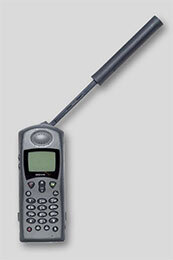 Satellite phone. Allows global communications even in the most remote regions.
DISTRESS BEACON
For safety, a Sarsat distress beacon is placed on the airship. If activated, the beacon emits a distress message indicating the balloon’s position. The signal is picked up by a satellite and transmitted to the monitoring service, which relays the alert to the base camp. Telephone communication with the balloon is always possible.
ASSISTANCE AND RESCUE
In the North Pole sector, assistance is provided by MI8 helicopters from the Russian Borneo station, established annually in April near the Pole. In the Magnetic North Pole sector, Twin Otter aircraft can operate from Resolute Bay (Canada) and over the Beaufort Sea; the same aircraft can take off from Inuvik on the Mackenzie Delta or from Prudhoe Bay in Alaska.

