WHAT WILL THE WEATHER BE LIKE TOMORROW?
Specialists are answering this question with increasing accuracy, but beyond 5 days, uncertainty looms…! Why? Because Earth is the most complex system there is: every cloud, every gust of wind, every agricultural or built surface, every ocean current – even deep down –, every ice floe contributes to the climate! It’s impossible to know everything, from the poles to the equator. Forecasting a seasonal trend will be possible, but never the weather 15 days from now, on a specific beach…
A GLOBAL OBSERVATION NETWORK
Across all continents, thousands of measurement stations weave an impressive network to determine temperature, wind, pressure, humidity, etc. Aircraft and weather balloons provide us with these values at altitude. At sea, ships and buoys record this data and inform us about currents. This is how meteorological calculation and forecasting centers are supplied.
EVEN FROM THE SKY
In space, several meteorological satellites, both polar-orbiting and geostationary (they orbit at the same speed as the planet, remaining “fixed” above the ground), fly over Earth and transmit images and atmospheric evolution to us. This global and instantaneous view, remarkably complementing ground measurements, is at the origin of forecasting advancements.
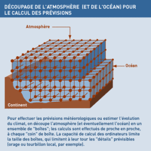
ACCURATE MODELS?
Meteorologists’ computers work with stored values and according to a pre-established method. To simulate the circulation of terrestrial “fluids,” the atmosphere and ocean are divided into “boxes,” and calculations are performed step by step. However, a tiny initial variation leads to completely different forecasts after hours of calculations! It is still necessary to refine the “boxes,” model the influence of terrestrial relief, living organisms, etc., and… await more powerful computers.