Polar Encyclopædia
GEOLOGY
The Arctic and Subantarctic regions are true witnesses of the geological history of the Earth with, on the menu a few kilometers under the hull of the Polar POD, the effusive basalt of the ocean floor covered with sediments; or on land, the lava of the volcanic islands, the intrusions of granites exposed by erosion, or the sedimentary rocks transformed in places into shales by the power of the movements of the earth's crust.
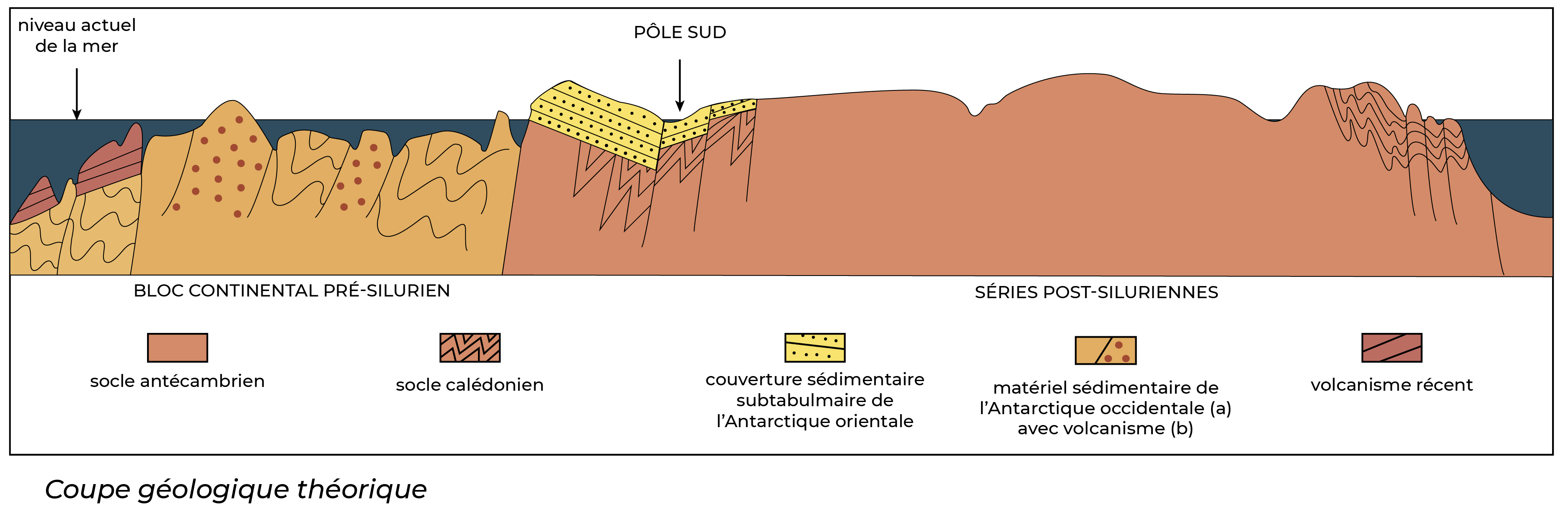
Schematic geological section of the Antarctic continent (Silurian = 32 to 250 million years old).
What you should know :
East Antarctica is an enormous continental shield (stable region of an ancient basement) composed of metamorphic rocks (which have undergone deformation), the oldest of which (gneisses of the Queen Maud and Enderby lands) date back nearly 3.5 billion years. This very rigid continental crust, related to Africa and Australia, is about forty kilometers thick and has had very little volcanism.
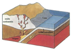
The clash of two plates of the earth's crust (subduction).
West Antarctica is much more recent and disturbed. This region is actually a mosaic of several continental blocks that drifted individually. The oldest ones date from the Cambrian (-570 million years (M.A.)) (Peninsula and Marie Byrd Land). This complex and still poorly reconstructed structure bears the traces of an alternation of oceanic trenches filled by several kilometers of sediments up to 13 km) and of folds (-220 to -80 M.A.). In addition to this, there is a subduction phenomenon: at an average rate of a few centimeters per year, the bottom of the Pacific Ocean "sank" into the Earth's mantle under the western margin of East Antarctica, giving rise to a volcanic bulge. Even today, Ross Island (Erebus volcano) and Shetland (Deception Island) are evidence of this powerful tectonics; at the end of the Scotia arc, the South Sandwich abyssal trench is a sign of the subduction still in progress. The last episodes of the history of this under-glaciated archipelago are linked to the genesis of the Andes Cordillera. The suture between East and West Antarctica is made by the long transantarctic chain, whose rocks - an accumulation of marine sediments - show several successive folds (since 600 BC).
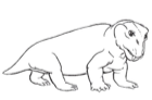
Lystrosaurus
Fossils help to clarify the history of Antarctica. In addition to the geological similarities found in India, Australia, Africa and South America, the study of these archives proves the existence of a supercontinent, Gondwana, about 200 million years ago. The Trans-Antarctic Mountains bear the mark of glaciations, 300 million years ago, followed by a temperate period: in the forests of that time lived amphibians and reptiles, whose remains were also found in Africa and India (Lystrosaurus). To the west, the sedimentary rocks of Alexander and James Ross Islands show the richness of the marine fauna of the Jurassic and Cretaceous periods (200 to 65 million years ago). More recent fossils have been discovered north of the Peninsula: remains of a giant penguin and marsupials, proving that Antarctica served as a bridge between South America (arrival of pocket mammals) and Australia.
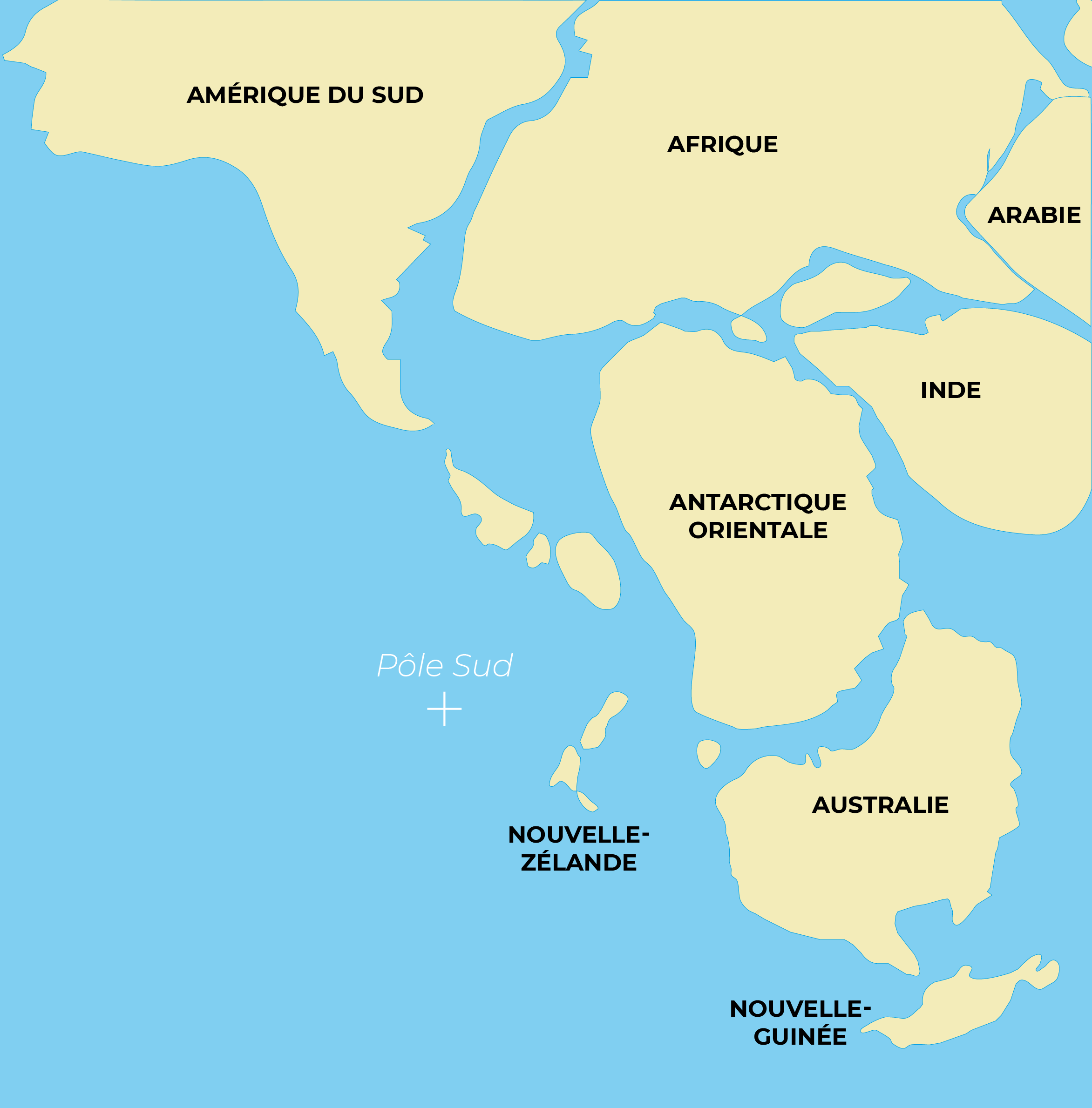
Gondwana about 150 million years ago: fragments of West Antarctica are uncertain.
The history of the Antarctic Ocean is inseparable from that of the continent. Gondwana began to fracture under the effect of intense volcanic activity about 170 million years ago, when the Earth was experiencing a hot and humid period. Several tens of millions of years later, Madagascar and the Seychelles broke away from Africa, as well as India, which began its spectacular ascent northwards, where it would become embedded in China, creating the Himalayas (a phenomenon that still continues today). The crack that opened 125 million years ago between South America and Africa will gradually become the Atlantic Ocean (with its submerged ridge). The Antarctic-Australia couple is still united some 70M.A. ago, but still has a subtropical climate. Finally, around 55 million years ago, a new branch of the Indian ridge (Eastern branch) isolates Australia which "goes up" to close the Timor Passage, cutting off the old water mass exchanges with the Pacific. When the Drake Passage finally opens, the powerful circum-Antarctic oceanic circulation starts its current and, about 41 million years ago, the southern glaciers are transformed into an ice cap (lava that erupted some 20 million years ago is characteristic of sub-glacial eruptions, proving that the cap existed at that time). From then on, the bases of oceanic and atmospheric circulations are in place for the birth of the terrestrial climates that we know today.
Suggested activities :
- Using a tracing paper and a world map, cut out and reconstruct the movements of the continents from 170 A.D. to the present day.
How can you explain that the Antarctic continent, when it served as a bridge between America and Australia, had a subtropical climate?
For more details
Books :
- Géologie de l’Antarctique - A. Cailleux.
- Guide Antarctique et Terres Australes – M. Foucard
- La géographie de l’océan austral – J.R. Vanney

Support the project with a donation
The Polar POD expedition is one of the stamp of the pioners, a human adventure coupled with a technological challenge, an oceanographic exploration never before carried out which will mark a milestone in the discovery of the oceans.
Thank you for your support !