Polar Encyclopædia
THE SOUTHERN OCEAN
On its way, the Polar POD will travel :
... vast oceanographic expanses, with zones of convergence between a mass of cold water coming from Antarctica and a mass of warmer water coming from the lower latitudes. It will be carried by an immense oceanic current like nowhere else on the planet...
What you should know :
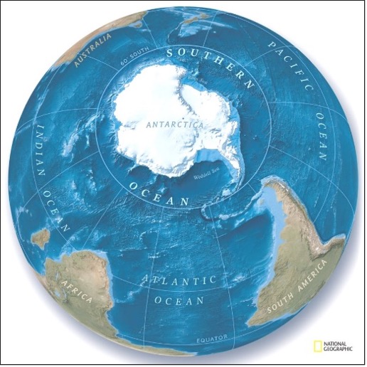
The world ocean is divided into three major parts: the Pacific Ocean, the Atlantic Ocean and the Indian Ocean. These vast expanses of marine water receive runoff from adjacent lands, according to the watersheds drawn by the continental landforms. In addition to these three major oceans, there is the Arctic Ocean, which corresponds to the bodies of water between the North Pole and the American and Eurasian continents. To the south of the globe, the presence of an Antarctic continent led to the long-held view that the waters surrounding it did not have sufficient specific characteristics to give them their own name, even though oceanographers had long since identified the existence of an ocean called the Southern Ocean. It is only recently that the name of Southern Ocean has been accepted by the IHO, international hydrological organization, and on June 8, 2021, on the occasion of the World Ocean Day, National Geographic recognized the existence of a fifth ocean whose waters extend between the Antarctic continent and the latitude of 60° South. The Southern Ocean thus defined from a geographical point of view coincides with the area covered by the Antarctic Treaty, but it is far from corresponding to all the specific characteristics identified by scientists who attribute to it a much wider area including the "roaring forties" and the "howling fifties", latitudes subject to extreme weather conditions.
The debate on the geographical limits of the Southern Ocean is still going on.
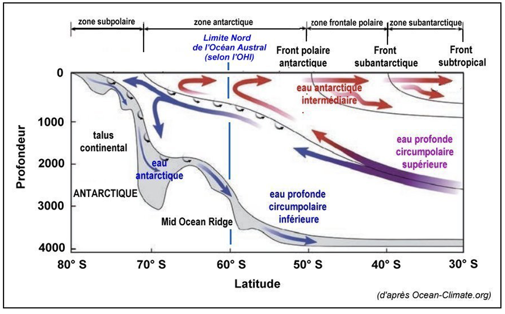
An example of a vertical schematic section of the Southern Ocean presented below illustrates the complexity of the ocean circulation in this region of the globe.
From a hydrological standpoint :
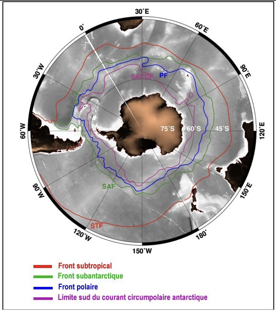
The Southern Ocean is the seat of important and complex movements of marine waters, both at depth and at the surface, due to the presence of the Antarctic continent and of cold and dense polar waters that tend to rise towards the north under the action of winds. On contact with warmer waters, this mass of cold, dense water plunges to the depths of the ocean. At the surface, we can observe fronts delimiting waters with different temperatures (between -2°C and +10°C depending on the latitude and the season), including: from north to south, a subtropical front, a sub-Antarctic front and a polar front. These fronts, whose position varies according to the season, can be favorable to a strong production of phytoplankton.
Near the Antarctic continent, the Southern Ocean freezes more or less depending on the season.
On the one hand, it receives a contribution of continental ice due to the calving of icebergs, and on the other hand, the freezing of sea water generates the ice pack. Satellite data allow us to assess the extent of the Antarctic ice pack on a daily basis.
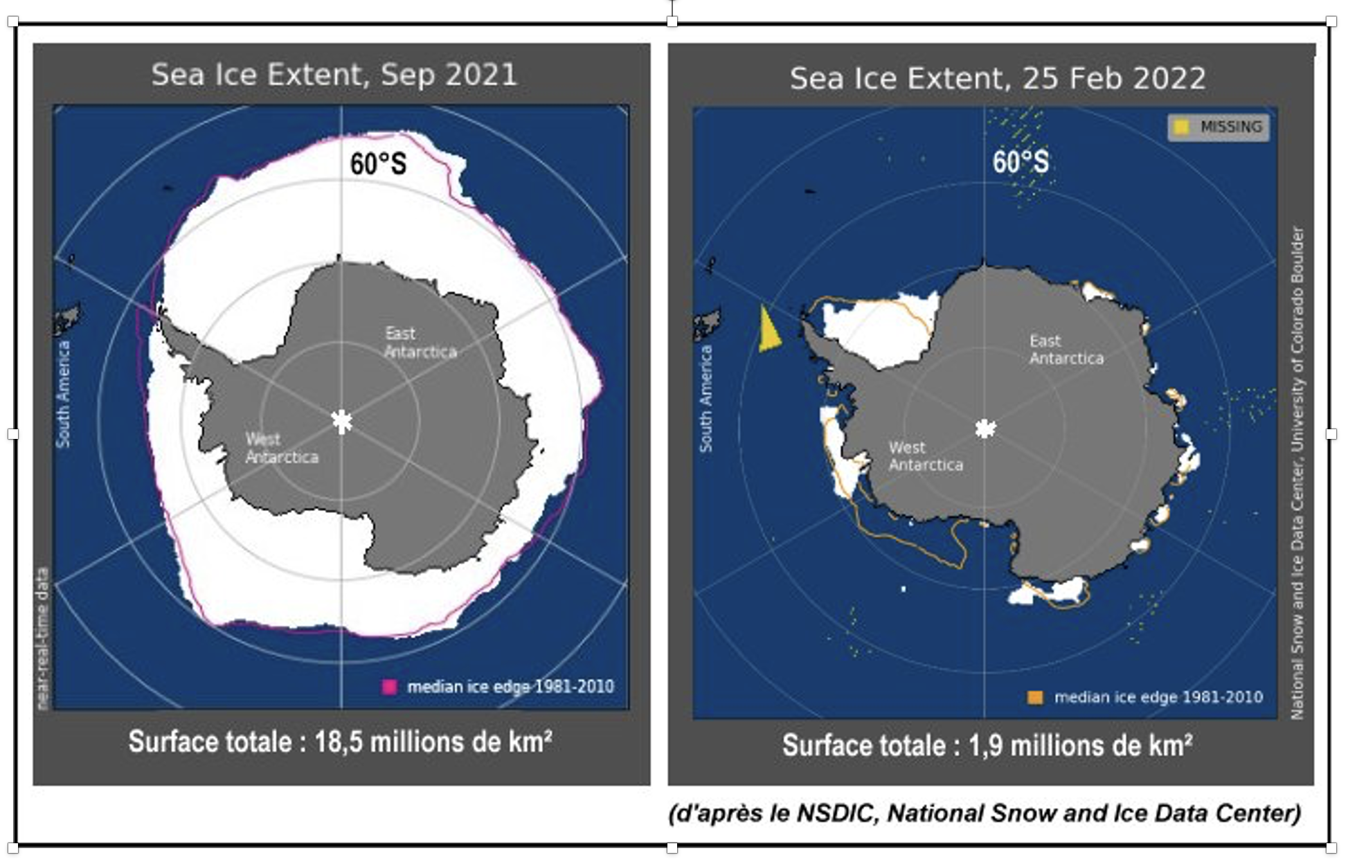
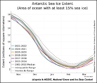
The minimum extension of the ice pack corresponds to February and the maximum to September, with a ratio of 1 to 10 between the summer and winter surfaces.
The most recent studies show that there is a tendency to decrease the surface of the Antarctic ice pack. Although this phenomenon is less marked than in the Northern Hemisphere for the Arctic ice pack, it is nevertheless perceptible.
We notice that the Southern Ocean (according to the definition which limits it to 60°S) is almost entirely covered with ice during the southern winter.
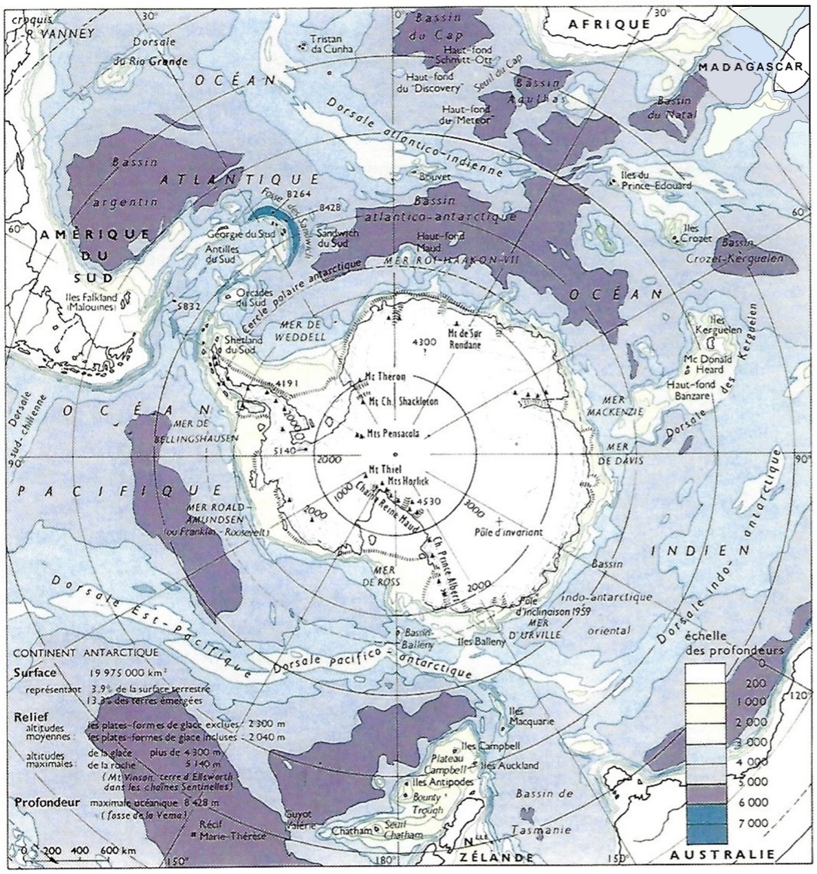
The above sketch was made by Jean-René Vanney who was a professor of geography at the Sorbonne and who took part in the bathymetric survey of the deep sea of the Southern Ocean in collaboration with the hydrographic services of the American navy, in the 80s.
Bathymetry :
The map illustrates the complexity of the ocean floor around the Antarctic continent.
The depth is mostly between 4000 and 5000 m with a maximum of 7635 m in the South Sandwich Islands Trough, near the Antarctic Peninsula (with some deeper points)
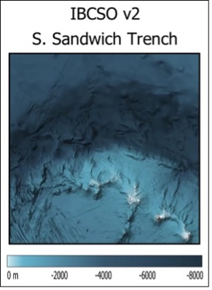
Currently, at the initiative of the International Hydrographic Organization, the Intergovernmental Oceanographic Commission and the Nippon Foundation, the "SEABED 2030" mission is underway, with the objective of mapping the entire global seafloor with a resolution of 100 m by 2030.
At the beginning of June 2022, results concerning the bathymetry of the Southern Ocean were published, as shown in the document opposite: bathymetry of the South Sandwich Islands Trough.
(source: International Bathymetric Chart of the Southern Ocean Version 2)
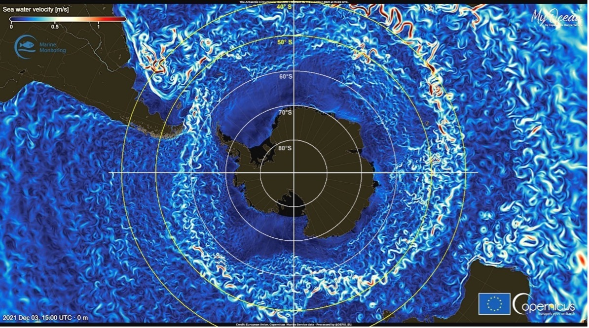
Antarctic Circumpolar Current (ACC)
Unlike the other great oceans, which are limited by the continents that border them, the Southern Ocean surrounds a continent and borders the southern ends of the Atlantic, Pacific and Indian Oceans.
At the edge of the Southern Ocean, pushed by the very strong westerly winds prevailing in the Howling Fifties, the Antarctic Circumpolar Current appears. This current, which is believed to have been born from the opening of the Drake Passage, between the southern tip of America and the tip of the Antarctic Peninsula, more than 30 million years ago, is the most powerful current in the world. Circulating from east to west, at a speed of between 1 and 10 km/h, its flow can reach 150 million m3/s (i.e. 150 Sv, the Sverdrup, Sv corresponding to 1 million m3/s). With a width of 200 to 1000 km, it exerts itself on a length of about 24000 km, corresponding to the circumference of the globe at its latitude by describing a multitude of circumvolutions. This cold water current absorbs an important part of the atmospheric CO2 and contributes strongly to the circulation of the deep waters of the world ocean.
Due to its specific characteristics, it plays a major role in the global climate and in the field of marine biodiversity. This current is not well known, because of the extreme conditions that prevail and that are not very favorable to permanent observation missions, hence the interest of the scientific community for the Polar POD drift.
Suggested activities
The Southern Ocean
- What is the cause of the deep currents that carry polar waters to the tropical ocean floor?
- What is the cause of the surface ocean currents?
- Where is the krill-rich zone located in this system?
For more details
Books :
- Glaces de l’Antarctique - C. Lorius
- La Voix des pôles - L. Lescarmontier
- La Machine Océan – JF. Minster
- Les animaux des pôles – F. Genevois
- Salut au grand Sud – I. Autissier & E. Orsenna
Miscellaneous:
- Blogs des hivernants de l’institut polaire : institut-polaire.fr
Support the project with a donation
The Polar POD expedition is one of the stamp of the pioners, a human adventure coupled with a technological challenge, an oceanographic exploration never before carried out which will mark a milestone in the discovery of the oceans.
Thank you for your support !