Polar Encyclopædia
THE SUBANTARCTIC ISLANDS
There is a world between ours and Antarctica. It is the one that is naturally called "Sub-Antarctica" and which has the particularity of having a large number of islands scattered in the "roaring forties" and "howling fifties". South Georgia, the Orkneys, the Falklands, the Kerguelens.... So many names that make you dream of these islands planted between two worlds, that of the ice pack and the subtropical convergence. And it is in this scenery that the Polar Pod will navigate.
THE FALKLANDS (OR MALVINAS)
What you should know:
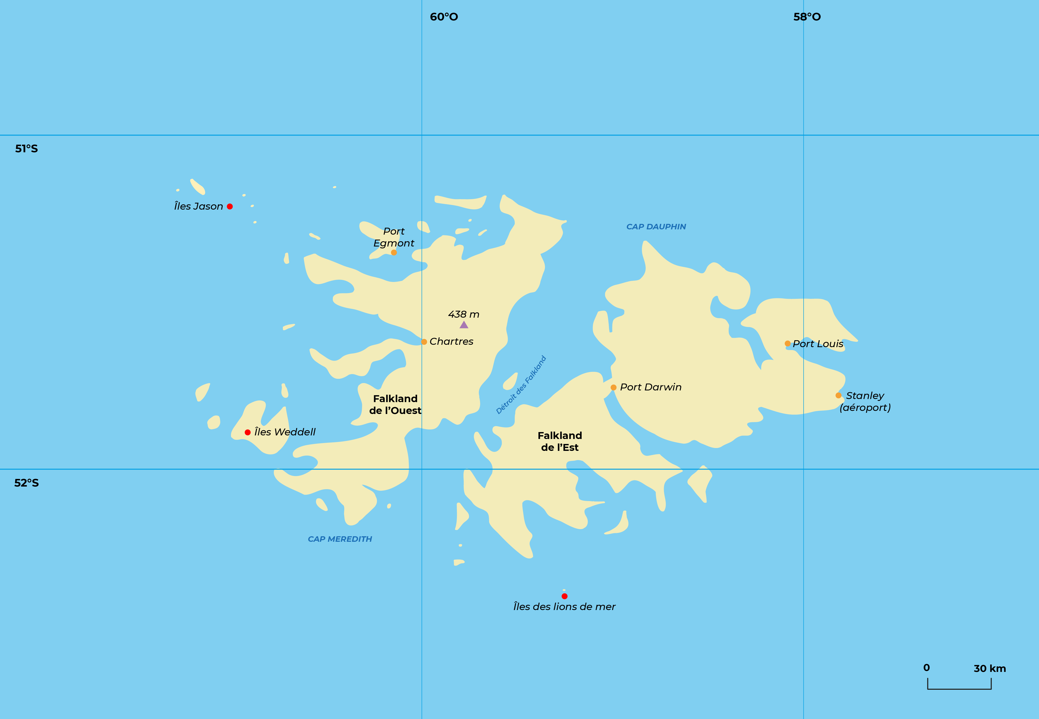
A little geography. The Falkland Islands, at 52° South and 60° West, just 350 km from the coast of Tierra del Fuego, are made up of 200 islets surrounding two large lands -the East and West Falklands- separated by a navigable channel. The total surface area of the islands is approximately 12,000 km² . These islands, which are in reality the summit of the American continental shelf, present a monotonous landscape of hills (highest point: 705 m) where ice is unknown. The almost permanent wind (30 km/h on average) can unleash unpredictable storms. Precipitation, despite its moderate importance (635 mm/year) falls in the Falklands in the form of fog and rain, for 270 days a year. But the thermometer shows that the archipelago is not really polar, with an average temperature of 6°C (-5° to +21°C) for a water temperature that varies between 3° and 11°C.
A bit of history. Would Ameriga Vespucci have seen the Falklands in 1502, or Camargo in 1540, or Davis in 1592, or Hawkins in 1594? What is certain is that the Dutchman Sebald van Weert positioned them in 1600 and named them Sebaldines. 90 years later, the privateer John Strong landed there and used for the first time the strait that separates the two main lands and named it Falkland Strait, in honor of the Viscount of Falkland, Treasurer of the Navy. Between 1698 and 1725, the French from Saint-Malo visited these islands several times, hence their other name of Falklands (Malvinas for the Argentines). Then in 1752, the Royal Academy of Paris asked the young Louis Antoine de Bougainville to search for the southern continent and to study the Patagonians. Bougainville chose the Falklands as an advanced base, where he disembarked with the Eagle and the Sphinx in February 1764 to found Port Louis on the East Island. This place was ceded to the Spanish two years later, in exchange for reimbursement of the costs of Bougainville's expedition, while the English in turn founded Port-Egmont on the West Island. The Spanish expelled them in 1771, but they re-established themselves there and took possession in the name of England in 1833, while the Argentinians, independent since 1816, had sent a governor there since 1820. In 1908, to confirm their claims to the south, the British added Georgia, the Sandwich Islands, the Orkney Islands and South Shetland to what they called the "Falkland Dependency", whose headquarters were located in the capital, Port Stanley, on the East Island. This long-standing quarrel was at the origin of the Falklands War between the British and Argentinians in 1982.
Living in the Falklands. Towards the middle of the 19th century, the English settlers, in order to face the weakening of the seal industry, were encouraged by their government to develop cattle breeding. To the wild cattle, abandoned by Bougainville and which did the job at first, they substituted the wool sheep, as in Australia. In 1882, 1,414 inhabitants watched over the commercial fate of half a million sheep! Today, the 2,840 inhabitants of the Falkland Islands, the majority of whom are British, the Kelpers, criss-cross their islands in Land Rovers, private planes, motorcycles or on horseback, under the protection of 2,000 soldiers, taking care to avoid a few minefields left by the Argentinians (about 18,000 undetectable devices!). But their wealth comes more and more from the squid fishing quotas that they sell to the Japanese, the Koreans and the Spaniards, transforming Port Stanley into one of the active centers of the Southern Hemisphere, as well as the only existing airport in the Austral and Sub-Antarctic islands.
Between the Andes and the Antarctic, the vegetation of the Falkland Islands includes some 150 flowering plants, including the tussock Poa flabellata which has been largely destroyed by ranchers, multiple mosses and lichens, but only a few trees. More than 100 species of birds frequent the archipelago. Many are terrestrial (geese, raptors, ...) or freshwater (plovers, herons, ...) and 29 are common seabirds in these latitudes: Magellanic penguin, royal penguin, penguin, gorfu, macaroni, black-browed albatross, sooty albatross, petrels, fulmars, prions, skuas, cormorants, gulls ... On the beaches, sea lions, elephant seals and sea lions also frolic.
SOUTH GEORGIA
What you should know:
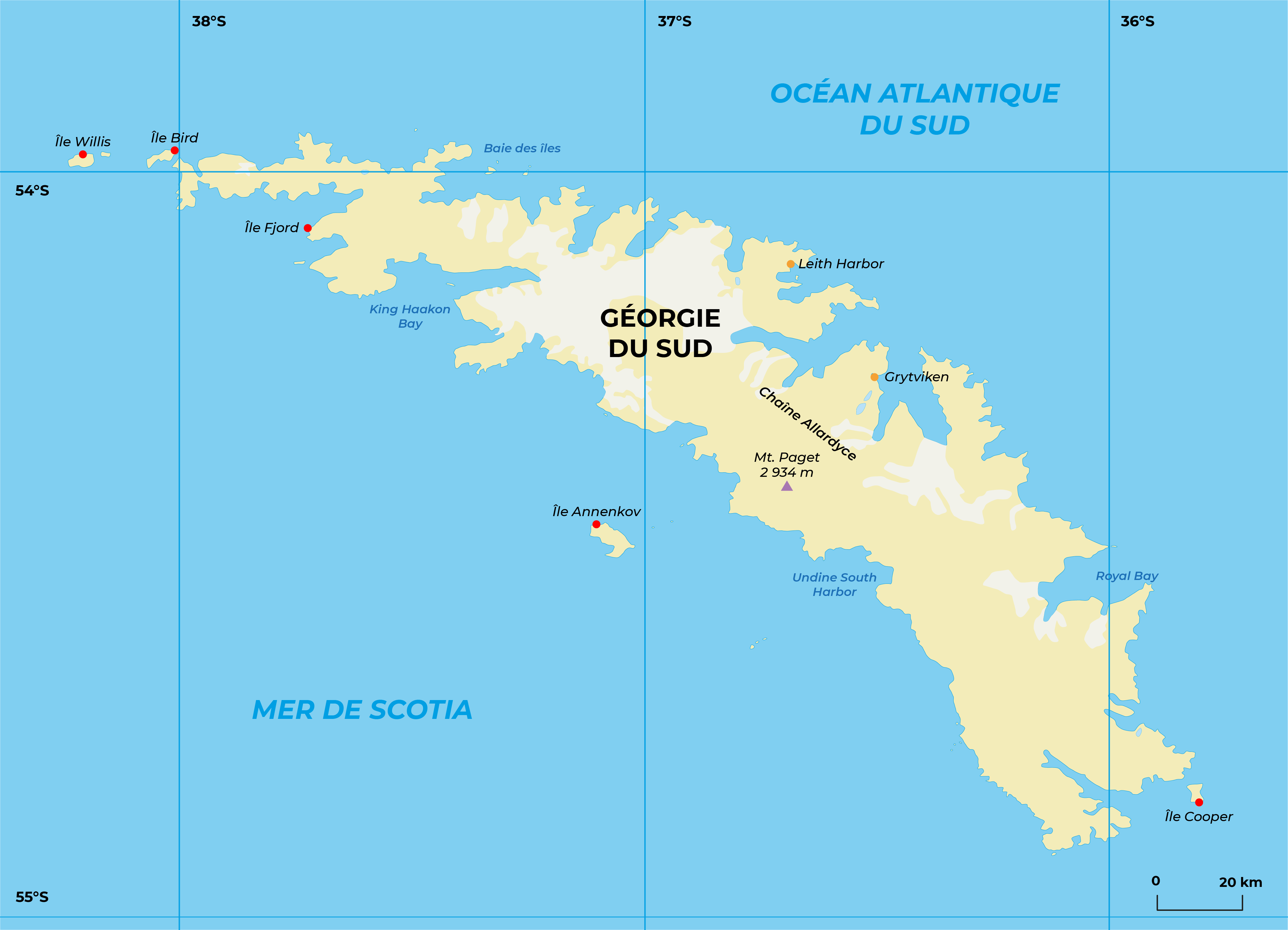
A little geography. South Georgia spreads its coasts around 54°S and 36°W, 2 000 km from Cape Horn and 1 500 km from Antarctica, south of the oceanic polar front (convergence). It is the highest of the sub-Antarctic islands (Mount Paget culminates at 2934 m in the Allardyce Range) and the second largest after Kerguelen. 60% of the island's surface is covered by snow or ice; some glaciers - and Georgia has 163 of them, but all are in retreat - flow into the sea where they release icebergs. The climate is cold, humid (1,500 mm/year in the form of rain and snow) and temperatures oscillate between -15° and +10°C. In winter, the ice pack rarely reaches these parts, but two meters of snow can cover the coast.
A little history. South Georgia was first sighted in 1675 by a London merchant, Anthony de la Roche (sometimes referred to as the Spaniard Antonio de la Roca...), then in 1756 by Sieur Duclos de Saint-Malo, who became Bougainville's second in command. Its final name was given by Cook, who landed there in January 1775 and took possession of it in the name of England. Later, in 1819, Bellingshausen discovered Annenkov Island and the southern coast, and German scientists came to Georgia for the International Polar Year of 1882-83. Finally, during his return to England, requested by his family, Shackleton died of a heart attack on board the Quest and was buried in Georgia. He is still buried there!
As early as 1786, sealers rushed to the southern Georgian waters, where they exterminated sea lions - for the skin - and elephant seals - for the oil. In a single summer (1800-1801), they brought back 112,000 skins! The 20th century was the year of the whale slaughter.
With the foundation of the Argentine Fishing Company by C.A. Larsen in 1904, the permanent occupation of the island began. The whaling stations of Leith, Grytviken, Stromness, Prince Olaf and Husvik totaled over a thousand inhabitants. Until 1966, more than 175,000 whales were killed, producing 10 million barrels of oil! The ruins of a movie theater, a hospital, factories and abandoned wrecks still haunt the Georgia shoreline.
Georgian Wildlife. 26 species of herbaceous vascular plants (in particular the Poa flabellata tussock and a rosaceous plant, Acaena adscendes), 125 mosses, 85 hepathic plants and 150 lichens grow in the valleys and on the coastline where the Macrocystis and Durvillea algae, called kelp, are exuberant. Five species of penguins (king, chinstrap, papuan, rockhopper and macaroni), 4 albatrosses, 13 petrels and prions, 1 cormorant, 1 skua, 1 tern, 1 gull and 1 chionis nest in Georgia, often in very large numbers (10 million macaroni!). Not to mention a duck and a terrestrial singing passerine, the pipit.
Sea lions, once exterminated, have repopulated the island (they are said to be 2 million!), as well as sea elephants (350 000). The other seals are, on the other hand, rare and passing through. If the introduced rabbits, sheep and ponies did not support the climate, the rat and the mouse became there a real plague for the avifauna, and 2 000 reindeers, resulting from animals brought in 1911, live in the mountains. The sea, very rich in fish, allowed the development of fishing after the disappearance of whales (ice fish, Antarctic "cod").
THE SOUTH ORKNEY ISLANDS
What you should know:
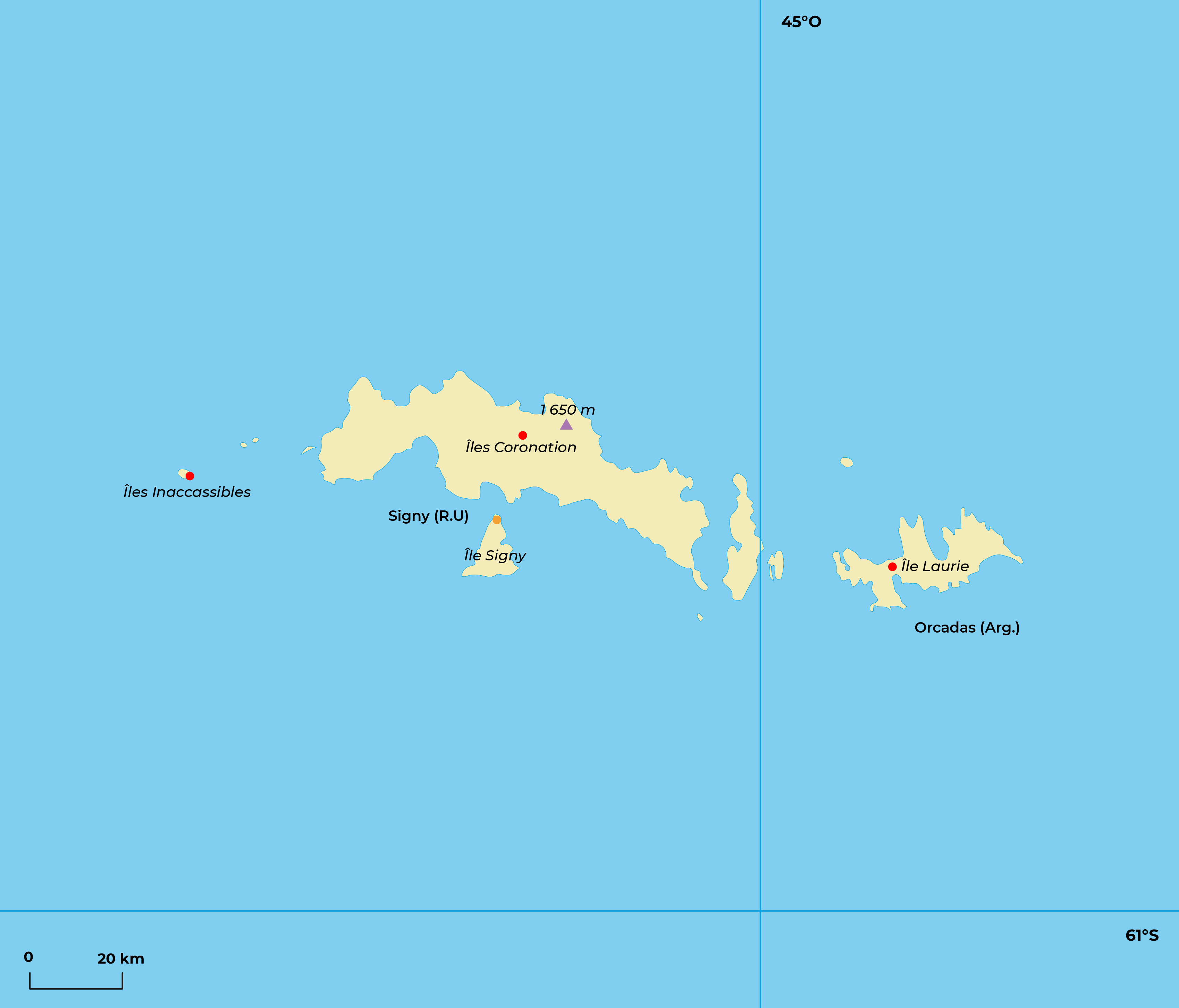
A little geography. The South Orkney Islands, at 61°S, 780 km south-east of South Georgia, lie in the natural extension of the Antarctic Peninsula. Around Coronation Island - a mountain with a rugged coastline, culminating at 1 650 m for an area of about 70 km2 - emerge the islands of Laurie, Powell, Signy and Inaccessible, not to mention a few islets. Orkney is almost entirely covered by glaciers and when the ice pack releases them during three months of summer, snow persists above 150 m of altitude. Although three times less watered than the sub-Antarctic islands themselves (400mm/year), snow, fog and storms set the scene for these already polar lands, where the temperature remains close to - 5 °C.
A little history. Discovered by an Englishman, G. Powell, on December 7, 1821, the Orkney Islands were on the route of several subsequent polar expeditions: Weddell in 1822, then Dumont d'Urville in 1838 and Larsen in 1892. In 1903 and 1904, W.S. Bruce wintered on Laurie Island during the Scottish National Antarctic Expedition. At the end of his stay, faced with the lack of interest from the British, Bruce gave his cabin to the Argentinians who then established a meteorological station there, thus creating the first scientific base in Antarctica (renamed Orcadas), which has been permanently occupied ever since. Between 1911 and 1930, whale hunters also settled in Orkney, and in 1947, the British returned to Signy Island.
The flora of Orkney is even poorer than that of the Sandwich Islands: apart from the polar canche, there are fewer species of mosses and lichens than in Graham Land, on the Antarctic Peninsula itself. The large Macrocystis algae of the subantarctic islands are replaced here by Phylogigas grandifolius. Several islets in Orkney have been declared Special Protection Areas.
If sea lions disappeared from Orkney for a while, they are now back in the company of Antarctic seals (Weddell, crabeater, elephant and leopard seals). Eighteen species of birds breed there, including 4 penguins (Adelie, Papuan, Chinstrap and rare macaroni).
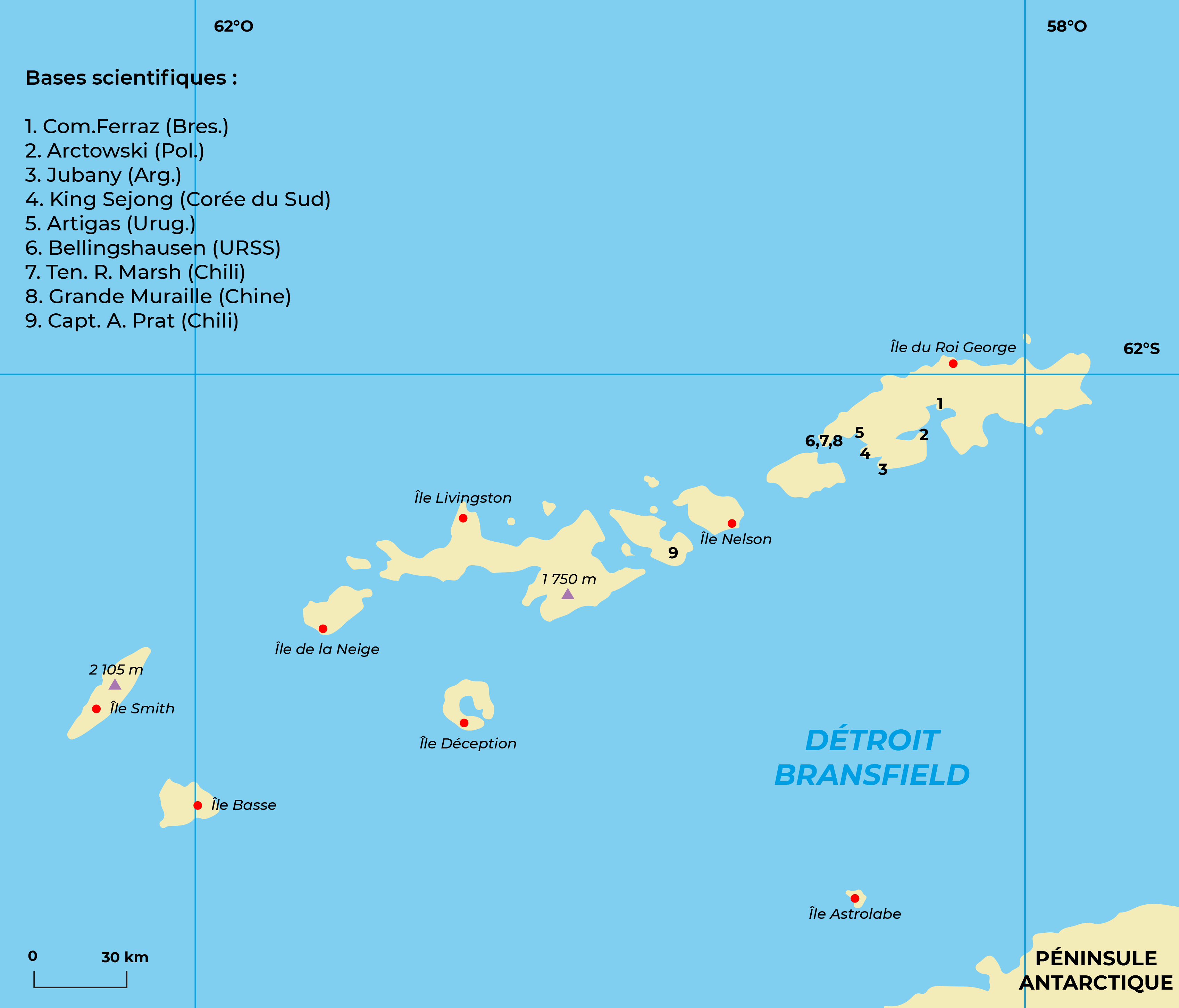
THE SOUTH SHETLAND ISLANDS
What you should know:
A little geography. South Shetland is 900 km from Cape Horn and 100 km from the west coast of the Antarctic Peninsula. A dozen islands follow one another between 61°S (Clarence Island) and 63°15'S (Low Island), following the general curvature of the Peninsula for more than 500 km. It is here, on King George Island, that the highest density of scientific bases is concentrated, on less than 1 000 km2. Steep fjords and glaciers mark the distinctly polar landscape, which has an Antarctic climate softened by the ocean; the peaks, which can reach 2,000 meters, are most often invaded by clouds that bring rain and snow; the coasts, foggy and very windy, are surrounded by pack ice for part of the year. For the last 5 years, there has been a notable warming which prevents the ice pack from developing. In Shetland, the temperature oscillates between 0°C and -7°C, with extremes of +15°C in summer to -30°C in winter.
The volcanic origin of the majority of the archipelago is not in doubt. The island of Deception, where fumaroles and hot springs are numerous, is a magnificent edifice of lava collapsed in its middle, drawing a gullied caldera invaded by the sea. It is even possible to bathe there, the water being heated by geothermal energy! Several eruptions have occurred there and it is still recommended to check the risks of volcanic activity before landing. Because here, the "fire belt" of the Pacific is closed...
A little history. The South Shetland Islands were discovered by the Englishman William Smith in 1819, then studied in more detail by Edward Bransfield the following year. The presence of whales, sea lions and elephant seals immediately attracted hunters who, within a few years, decimated the herds. Commander Charcot visited it with the Pourquoi pas? in 1908. Eight years later, Shackleton's expedition, in distress after the wreck of the Endurance, took refuge on Elephant Island where it camped for several months while waiting to head for South Georgia. And it was again from Deception Island that H. Wilkins' plane took off in 1928, for the first flight over Antarctica.
Since the last war, scientists have taken over from the whaling industry on Shetland: the first base was installed by the British in 1944 on Deception Island. Today, although Chile, Great Britain and Argentina still claim these islands (claims frozen by the Antarctic Treaty of 1959), it is Argentine, Brazilian, Chilean, Polish, Chinese, Soviet, Korean, Uruguayan, Spanish and Peruvian researchers who "populate" the archipelago, with a dozen bases on King George Island alone! This is not without causing some problems of neighborhood and pollution, not to mention the redundancy in scientific programs. This island is also frequently visited by tourists, transported from South America by planes and cruise ships.
The fauna and flora of South Shetland is comparable to that of the Antarctic Peninsula: patches of mosses and lichens accompanied by tufts of polar canche and sago grass shelter some invertebrates. Seventeen species of birds, including 4 penguins, breed here, forming large colonies; sea lions and elephant seals are found on land, while crabeater and Weddell seals take advantage of the ice floes.
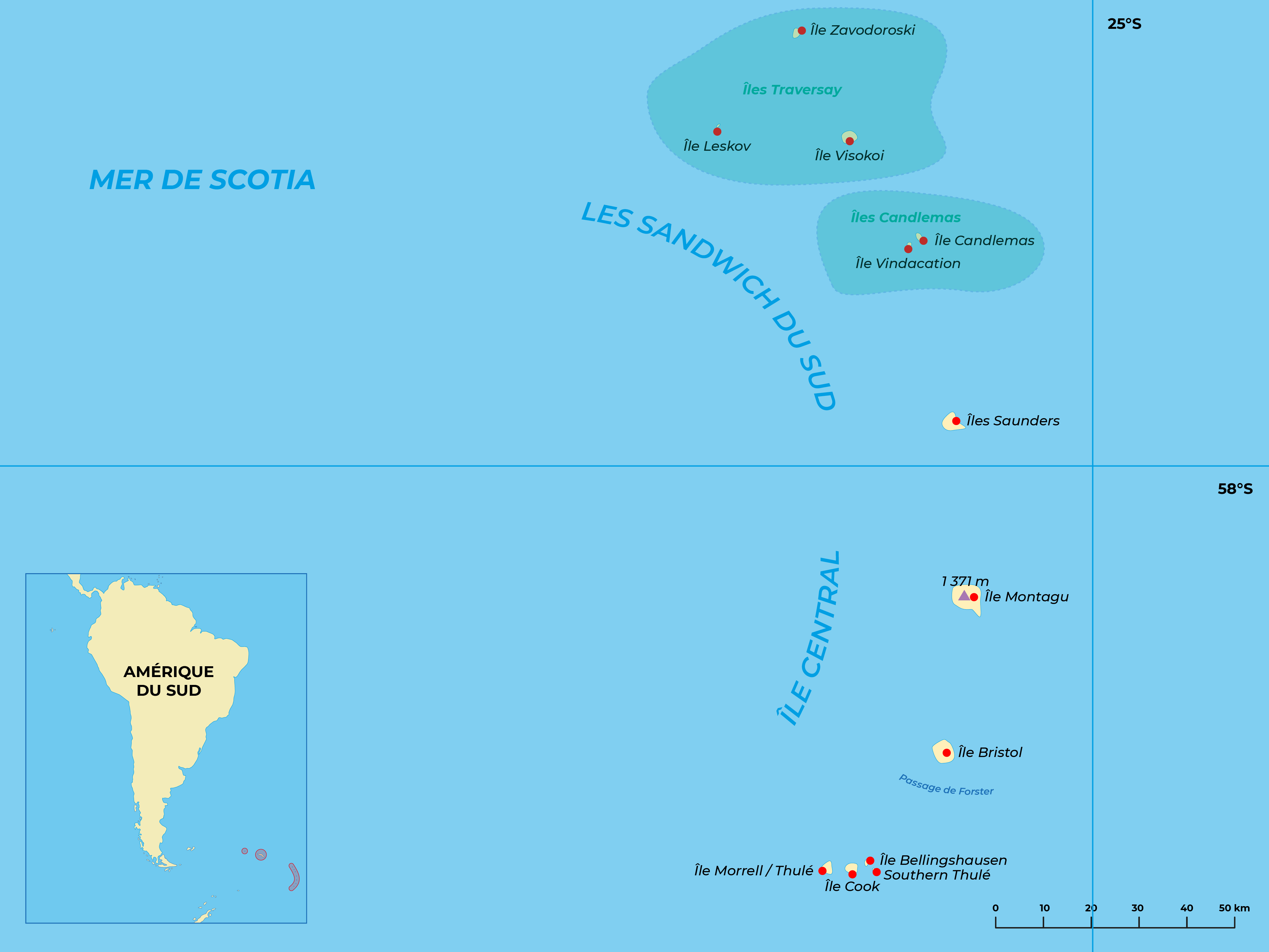
THE SOUTH SANDWICH ISLANDS
What you should know:
A little geography. The South Sandwich Islands are lost in the ocean, 2,300 km from Cape Horn, 1,300 km from Antarctica and 4,300 from South Africa, between 56° and 59°30 S, and 26° and 28°W. This archipelago closes the Scotia arc at 500 km from Georgia, in a sea encumbered with ice from July to October. Eleven main islands form, over 400 km long, an arc open to the west, whose largest lands are largely ice covered. Located very south of the Antarctic Convergence and on the path of the big depressions, fog and snow are frequent and temperatures oscillate between + 3° and -5°C in the north and -1° and -11°C in the south.
The South Sandwiches have an active volcanism: (sulfurous fumaroles, solfataras, etc.) witnessing the sinking of the Atlantic plate under its Antarctic neighbor. The basaltic lava is reminiscent of that of Patagonia and Antarctica. At the foot of the arc, at the bottom of the ocean, this subduction is signed by one of the deepest abyssal trenches in the world (-8 265 m).
A little history. On January 31, 1775, James Cook, aboard the Resolution, saw an island (Cook Island) and a few other rocky promontories between fog and ice; he determined their positions with an extraordinary precision for the time. On December 21, 1819, Taddeus Bellingshausen, at the head of the Vostok and the Mirny, completed Cook's discovery: he discovered the three northern islands, took multiple detailed sketches and underlined the active volcanism of the archipelago. Then, until the 20th century, only a few rare sealers visited these inhospitable lands, terribly cut and almost unapproachable, exterminating sea lions between 1875 and 1892. From 1911 to 1936, several ships approached the archipelago to hunt cetaceans, without much success. Scientific campaigns also multiplied: Deutschland (1911), Endurance (1914), Quest (1922), Discovery Il (1930).
Currently, the South Sandwich Islands are administered by the British (Falkland Islands Dependency), but still claimed by Argentina. After the extermination of the sea lions at the end of the last century, the birth of the first baby was only reported in 1957. Since then, presumably taking advantage of Georgia's stock, the population has been gradually rebuilding. Elephant seals congregate here in large numbers and there are also small numbers of Weddell seals and leopard seals. Ten species of seabirds nest in the Sandwiches, constituting an avifauna very similar to that of Orkney and Shetland.
Cape Damselflies and Antarctic fulmars are abundant; the presence of snow petrels, Wilson's petrels, giant petrels, skuas, cormorants and terns is also characteristic of the Antarctic zone, making the absence of chionis surprising. In addition, there are macaroni, adelie, papuan and chinstrap penguins, the latter forming the largest penguin population in the world.
Long ignored, the flora of the Sandwiches seems very poor, constituted by 13 species of algae, 27 of lichens, 31 of mosses, 12 of liverworts and only one grass. The whole archipelago has not been the object of any introduction of plants or animals.
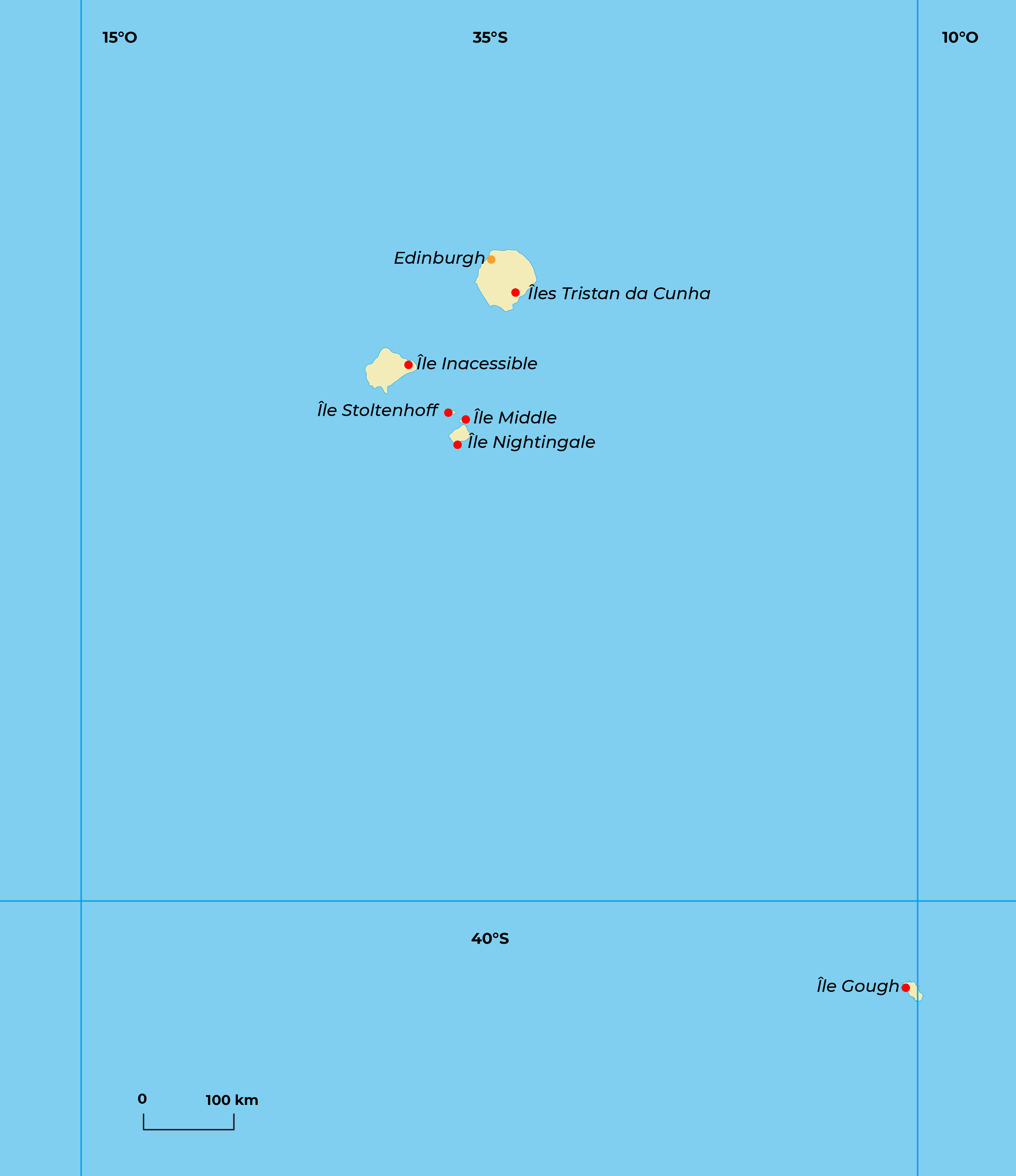
TRISTAN DA CUNHA
What you should know:
A little geography. The island of Tristan da Cunha is located at 37°05' South latitude and 12°20' West longitude, between South America (4 200 km) and Cape Town (3 100 km). The slopes of this volcano born on the eastern flank of the Mid-Atlantic Ridge fall steeply into the sea, offering no possibility of a harbor. Gusts of wind (up to 150 km/h) and rain (1,500 mm/year) characterize the temperate climate of this isolated island (15°C on average), where 300 inhabitants live cut off from the rest of the world, straddling the subtropical oceanic convergence and on the edge of the subantarctic world. A setting that reminds us of the French island of Amsterdam, in the Indian Ocean (French Southern and Antarctic Lands - TAAF).
A little history. The island, discovered in 1506 by the Portuguese admiral Tristan da Cunha, was annexed by Great Britain on August 14, 1816 and became part of the Dependency of St. Helena, from where the settlers who founded the town of Edinburgh on Tristan left. The Challenger visited Tristan in 1873, during its circumnavigation campaign. In the days of the sailing navy, this land in the heart of the South Atlantic served as a stopover for whalers, who found food and drinking water there. During the war (1942), the British installed a weather station on Tristan, which is maintained today by the South Africans. 45 km to the south, the deserted islands of Inaccessible and Nightingale are attached to Tristan da Cunha. Even further south, the South Africans manage a sub-Antarctic base on Gough Island.
The inhabitants of Tristan da Cunha, who depend on the British crown, are now about 250 and live from cattle (oxen, pigs, sheep) and some crops that grow under the shelter of low lava walls (potatoes, vegetables, fruit trees). In addition, there is a small, relatively recent lobster freezing industry. In 1962, an unexpected volcanic eruption forced all the inhabitants to evacuate the island for a few months.
Fauna and flora. The slopes of Tristan da Cunha are covered by a grassland made up of a large grass species, Spartina arundinacea; mosses and ferns are also found. Peat bogs develop in the heights. But the most characteristic is without any doubt the Phylica, an endemic tree, unfortunately become rare (another Phylica grows on the French southern island of Amsterdam). The coasts are invaded by Macrocystis algae.
Sea lions and seabirds - leaping gorfou, albatrosses, skua petrels, terns, etc. - breed in the archipelago where there are also some land birds. Rats, introduced by accident in 1882, have become on Tristan, as in several subantarctic islands, a real plague.
THE OTHER ISLANDS
What you should know:
The distribution of the continents on Earth is very dissymmetrical: between 45° South latitude and the Antarctic Circle, the ocean covers more than 90% of the globe, while in the north, more than half of the surface is occupied by dry land at the same latitudes. Thus, all the sub-Antarctic islands (about twenty archipelagos) do not total 40 000 km2; less than the surface of Switzerland! The climate is directly linked to the temperature of the sea (successive convergences) and to their progressive distance from the polar continent. Swept by lows that wrap around the Earth without the slightest obstacle (westerly wind belts), these regions experience cold, rainy weather, even stormy and rapidly changing, with a clear decrease in precipitation as one moves closer to the dry and icy Antarctic. As if to add to their austerity, most of the sub-Antarctic islands are of recent volcanic origin and their relief is rugged, even jagged, often offering only almost inaccessible and dangerous coasts; glaciers are numerous, and some of them reach the sea from the latitude of Kerguelen.
Distant possessions. In the South Atlantic, the islands of the arc of Scotia are administered by the United Kingdom.Bouvet Island (or Bouvetoya), very isolated and discovered in 1649 by the Frenchman Bouvet deLozier, belongs to Norway; further north, the group Tristan da Cunha and Gough is again British, but managed by South Africa. Around New Zealand in the South Pacific and belonging to it, are the Campbell, Auckland, Antipodes, Bounty, Chatham and Snares islands; Macquarie Island, on the other hand, is an Australian possession, as are Heard and Macdonald, carried by the Kerguelen submarine plateau, in the South Indian Ocean. Emerging from this same drowned relief, the Kerguelen archipelago is part of France (TAAF), as well as 1 500 km west of the Crozet Islands and, 1 400 km north of it, Saint-Paul and Amsterdam; finally, Marion Island and Prince Edward Island are South African.
The French Southern and Antarctic Lands (TAAF) created by the law of August 6, 1955 (composed by the 3 archipelagos of the Southern Indian Ocean and by the French Antarctic sector of Terre Adélie limited by the longitudes 136 °E and 142 °E) are placed under the authority of a chief of the territory and depend on the DOM-TOM (French Overseas Departments and Territories). The French government maintains 4 permanent scientific bases there: Port-aux-Français in Kerguelen, Alfred-Faure in Crozet, Martin-de-Viviès in Amsterdam, Dumont d'Urville in Terre Adélie. Each year, in the absence of any air link, a supply ship - also a research vessel - the Marion-Dufresne, relieves the staff of the islands (a few dozen men in each base) and a polar ship, the Astrolabe, that of Terre Adélie. Kerguelen, the size of Corsica, is the largest of all the Austral Islands (not to be confused with the Austral Islands of French Polynesia!). Each mission sent to the TAAF spends a long wintering period there, which begins and ends with a short summer campaign. Marine biology, botany, zoology, human biology, oceanography, geophysics, geology and meteorology are studied by teams of researchers since the installation of the bases in the 60s. At present, some satellites are also followed.
Philately (stamps are only issued for use in the TAAF) and fishing (lobster and fish quotas) are the only "commercial" activities.
Suggested activities:
- Compare South Georgia to the Falklands: why is the 2 degree latitude difference so critical?
- Why is the wildlife richer in South Georgia than in the Falklands?
- What was the real stake of the Falklands during the war between the British and the Argentinians in 1982?
- Why have no plants or animals been introduced to the South Sandwich Islands?
- Do you think that the volcanism of the South Shetlands significantly warms the climate?
- How do you explain the importance of winds and storms in these subantarctic areas?
- What are the missions of the TAAF?
For more details :
Literature:
- Salut au Grand Sud – I. Autissier & E. Orsenna
- Damien - Janichon
Guides :
- Guide des oiseaux et mammifères des Terres Australes et Antarctiques Françaises. – J. Prévost & JL Mougin
- Guide Antarctique et Terres Australes – M. Foucard
Site :
- French Southern and Antarctic Lands : taaf.fr
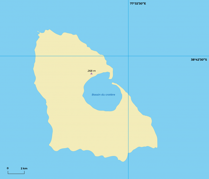
Ils Saint-Paul
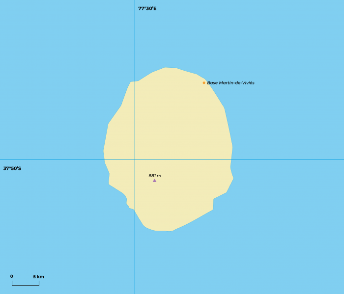
Ile Amsterdam
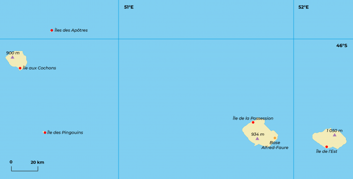
Iles Crozet
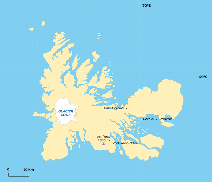
Iles Kerguelen
Support the project with a donation
The Polar POD expedition is one of the stamp of the pioners, a human adventure coupled with a technological challenge, an oceanographic exploration never before carried out which will mark a milestone in the discovery of the oceans.
Thank you for your support !