

AN OCEAN HIDDEN UNDER THE ICE PACK
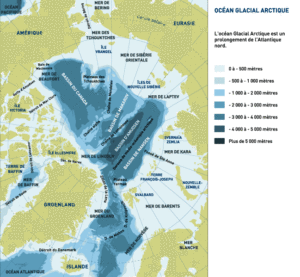
The Arctic Ocean, centred on the Geographic North Pole, has an area of about 13,000 sq. km. Scientists only began to explore the floor of this ocean a few decades ago. This ocean is rather like the Mediterranean: it is almost closed off by the Bering Strait and surrounded by the land masses of the Northern Hemisphere, so it is only really open to the outside via the stretch of Atlantic Ocean lying between Greenland and Scandinavia.
ABYSSAL OCEANIC BASINS…
The central part of the Arctic Ocean comprises a series of basins between 3,000 and 5,000 metres deep separated by subsea mountain ridges whose summits rise to within 1,000 metres of the surface. This complex morphology is the result of a long and tumultuous geological history.
… … BORDERED BY SHALLOWER WATERS WITH ARCHIPELAGOS
To the north of the Eurasian landmass, there is a vast continental shelf that in some places stretches 1,300 km from the coast. Several large islands emerge from these shallower coastal waters. To the north of the American continent, on the other hand, lies the multitude of islands that form the Canadian archipelago, split by deep channels dug even deeper by glaciers.

GEOGRAPHY: THE MOTHER OF OUR CLIMATE
The Arctic Ocean, the northerly extension of the Atlantic, is almost a maritime cul de sac, but the wide opening that stretches from Greenland to Scandinavia allows huge masses of water to circulate both near the surface and at great depth. Upward and downward currents generate major heat exchanges that are a key to the Northern Hemisphere climate.
MARINE CURRENTS: REDISTRIBUTING HEATDES COURANTS MARINS : DES DISTRIBUTEURS DE CHALEUR
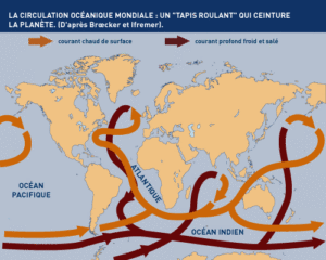
The world’s oceans are not immobile masses of water, they involve surface and ocean floor currents that keep water moving continually.
The surface currents (speed: 0.1 to 0.5 metres per second) are caused by the action of the wind. The deep currents, which are much slower, are caused by differences in the density of seawater (themselves due to salinity or temperature). All these currents are also deviated by the Earth’s rotation (the Coriolis effect).
Oceanic water in the tropics receives a great deal of heat from the sun. This warmer water is carried by surface currents towards the higher latitudes, where the heat rises into the atmosphere. As a result, the water cools and becomes heavier, convecting downwards and being carried back towards the tropics by deep currents (the North Atlantic Drift Current, for example).
All this means that the mass of oceanic water warms the climate in colder regions and lowers temperatures in tropical climes. So an understanding of the circulation patterns in the world’s oceans is essential to a better understanding of the Earth’s climate. Any variation in the ocean currents will have an impact on the climate.
The bottom of the northern submarine sills are marked by the currents…
THE ARCTIC OCEAN: CUL DE SAC OF THE WORLD OCEAN
The floor of the immense Arctic Ocean Basin communicates — via a narrow seabed furrow (the Lena Trough), which is up to 4,000 metres deep in places – with the Scandinavian Basin (only a third its size) that extends across between the Svalbard Archipelago, Norway, Iceland and Greenland. This Scandinavian Basin is open to the Atlantic over the wide channels on either side of Iceland.
The amount of water that can enter the Arctic Ocean via the Bering Strait, driven by the Bering Sea gyratory current, is all surface water, because the flow is reduced by a sill only 40 metres from the surface. But over on the Atlantic side, 200 times more water can enter the Arctic Ocean: the opening available for the Norway branch of the powerful North Atlantic Current is quite wide and the only sills lie 200 metres and 500 metres down, respectively. So while the Antarctic Ocean forms a sort of roundabout for the world’s oceans, the Arctic Ocean is a cul de sac where the water flow is turned back. Water can only get out one of two ways: via the deep, from the Norwegian Sea towards the Atlantic, or on the surface thanks to the Greenland and Labrador Currents. Almost no water flows southwards through the Bering Strait to the Pacific.
DEEP CURRENTS AND SURFACE CURRENTS
In the Arctic Ocean, the circulation at depth is very different to the circulation on the surface. All the water arriving from the North Atlantic eventually returns to that ocean, because it cannot escape to the Pacific via the Bering Strait. When the northbound flow reaches Svalbard, the Atlantic waters (saltier and heavier, even though they are warmer) dive down under the polar waters on the surface of the vast Arctic Basin. The zone where this occurs is clearly delineated by a sinuous hydrological border known as the Polar Front. The Atlantic waters that dive down into the vast boreal basin always show temperature readings above 0°C and salinity higher than 35%. First of all, this mass of intermediate water flows along the Eurasian slope and then, trapped by a succession of subsea basins, turns around and exits the Arctic Ocean towards the Scandinavian Basin and the Greenland Sea via the very deep Lena Trough. Right at the bottom of the Eurasian Basin (the deepest), along the continental shelf, a layer of negative-temperature water remains, unable to pass through the Lomonossov Ridge.

…alors que les plaines, calmes, ne le sont pas.
THE ARCTIC BASIN: THREE DISTINCT LAYERS OF WATER
En général, une couche superficielle d’environ 150 m d’épaisseur, relativement douce (à cause des apports environnants) et dont la température demeure toujours négative, recouvre une couche intermédiaire qui descend jusque vers 900 m, plus chaude (> 0° C) et plus salée (> 35%°); puis jusqu’au fond, circule une couche profonde à peine moins salée, mais de température à nouveau légèrement négative.
D’autres subdivisions, parfois saisonnières, apparaissent dans les mers nordiques.
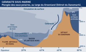
A SUBSEA CATARACT
The waters lying at depth in the Arctic Ocean can escape over the subsea sills in the Denmark Strait and next to the Shetlands. In these places, the waters flow over in giant subsea cataracts, giving birth to the deep North Atlantic Current.
Just to the south of the Greenland-Iceland sill, the water coming over forms a gigantic cataract 2,000 high and 200 km wide. Once it reaches a depth of 3,500 metres it forms the deep branch of the North Atlantic Current. During its descent, the cataract water probably mixes with warmer water (particularly coming up from the Western Mediterranean) and as result the water forming the deep North Atlantic Current is not quite as cold as the water in the deep current flowing up from the Antarctic, which therefore forms a distinct layer above it.
The subsea cataracts mentioned above have a water flow at least 25 times that of the Amazon River.
FLOW RATES OF THE MAJOR OCEANIC CURRENTS :
- Antarctic Circumpolar Current : 130 Sv*
- Gulf Stream : 90 Sv
- ubsea cataract in the Denmark Strait : 2,5 à 5 Sv
- ering Sea Current : environ 1 Sv
- All the world’s rivers combined : 1 Sv
* 1 Sv (Sverdrup) = 1 million de m3/s
THE ARCTIC OCEAN: STILL MANY MYSTERIES …
The Arctic Ocean is one of the least studied in the world. Although polar, it is totally different from the Antarctic Ocean in many aspects: its wide continental platforms, its active opening (dorsal), its extension to the pole, its large inflow of fresh water by the rivers, its own ice dynamics …
Water circulation, freeze-up and thaw processes are still very hypothetical. Modeling of the Arctic Ocean on computer poses serious problems; in particular, small scale phenomena are poorly known. However, this ocean plays a major role in the global climate – and even more so in Europe – because it produces a large part of the world’s deep water and must “respond” to human activities, most of them relatively close.

