Polar Encyclopædia
THE ARCTIC OCEAN AND THE OCEAN CURRENTS
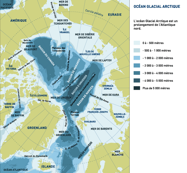
ABYSSAL OCEANIC BASINS…
The central part of the Arctic Ocean comprises a series of basins between 3,000 and 5,000 metres deep separated by subsea mountain ridges whose summits rise to within 1,000 metres of the surface. This complex morphology is the result of a long and tumultuous geological history.
… BORDERED BY SHALLOWER WATERS WITH ARCHIPELAGOS
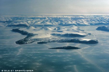
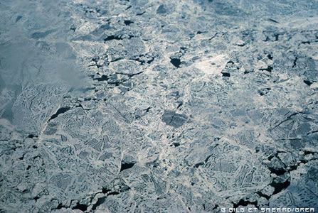
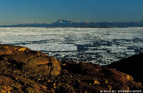
To the north of the Eurasian landmass, there is a vast continental shelf that in some places stretches 1,300 km from the coast. Several large islands emerge from these shallower coastal waters. To the north of the American continent, on the other hand, lies the multitude of islands that form the Canadian archipelago, split by deep channels dug even deeper by glaciers.
GEOGRAPHY: THE MOTHER OF OUR CLIMATE
The Arctic Ocean, the northerly extension of the Atlantic, is almost a maritime cul de sac, but the wide opening that stretches from Greenland to Scandinavia allows huge masses of water to circulate both near the surface and at great depth. Upward and downward currents generate major heat exchanges that are a key to the Northern Hemisphere climate.
THE ARCTIC OCEAN: CUL DE SAC OF THE WORLD OCEAN
The floor of the immense Arctic Ocean Basin communicates — via a narrow seabed furrow (the Lena Trough), which is up to 4,000 metres deep in places – with the Scandinavian Basin (only a third its size) that extends across between the Svalbard Archipelago, Norway, Iceland and Greenland. This Scandinavian Basin is open to the Atlantic over the wide channels on either side of Iceland.
The amount of water that can enter the Arctic Ocean via the Bering Strait, driven by the Bering Sea gyratory current, is all surface water, because the flow is reduced by a sill only 40 metres from the surface. But over on the Atlantic side, 200 times more water can enter the Arctic Ocean: the opening available for the Norway branch of the powerful North Atlantic Current is quite wide and the only sills lie 200 metres and 500 metres down, respectively. So while the Antarctic Ocean forms a sort of roundabout for the world’s oceans, the Arctic Ocean is a cul de sac where the water flow is turned back. Water can only get out one of two ways: via the deep, from the Norwegian Sea towards the Atlantic, or on the surface thanks to the Greenland and Labrador Currents. Almost no water flows southwards through the Bering Strait to the Pacific.
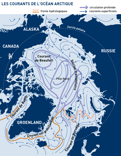
DEEP CURRENTS AND SURFACE CURRENTS
In the Arctic Ocean, the circulation at depth is very different to the circulation on the surface. All the water arriving from the North Atlantic eventually returns to that ocean, because it cannot escape to the Pacific via the Bering Strait. When the northbound flow reaches Svalbard, the Atlantic waters (saltier and heavier, even though they are warmer) dive down under the polar waters on the surface of the vast Arctic Basin. The zone where this occurs is clearly delineated by a sinuous hydrological border known as the Polar Front. The Atlantic waters that dive down into the vast boreal basin always show temperature readings above 0°C and salinity higher than 35%. First of all, this mass of intermediate water flows along the Eurasian slope and then, trapped by a succession of subsea basins, turns around and exits the Arctic Ocean towards the Scandinavian Basin and the Greenland Sea via the very deep Lena Trough. Right at the bottom of the Eurasian Basin (the deepest), along the continental shelf, a layer of negative-temperature water remains, unable to pass through the Lomonossov Ridge.
THE ARCTIC BASIN: THREE DISTINCT LAYERS OF WATER
The Arctic Ocean has three distinct layers. In general there is a surface layer about 150 metres thick, with low salinity (because of local freshwater input) and always at temperatures below 0°C. Then comes an intermediate layer down to about 900 metres comprising warmer (> 0°C) and saltier (> 35%) water. And from there to the ocean floor the water is almost as salty but the temperature is once again slightly negative.
Other subdivisions can also be observed in Nordic waters, depending on the season.
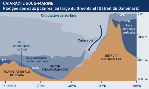
A SUBSEA CATARACT
The waters lying at depth in the Arctic Ocean can escape over the subsea sills in the Denmark Strait and next to the Shetlands. In these places, the waters flow over in giant subsea cataracts, giving birth to the deep North Atlantic Current.
Just to the south of the Greenland-Iceland sill, the water coming over forms a gigantic cataract 2,000 high and 200 km wide. Once it reaches a depth of 3,500 metres it forms the deep branch of the North Atlantic Current. During its descent, the cataract water probably mixes with warmer water (particularly coming up from the Western Mediterranean) and as result the water forming the deep North Atlantic Current is not quite as cold as the water in the deep current flowing up from the Antarctic, which therefore forms a distinct layer above it.
The subsea cataracts mentioned above have a water flow at least 25 times that of the Amazon River.
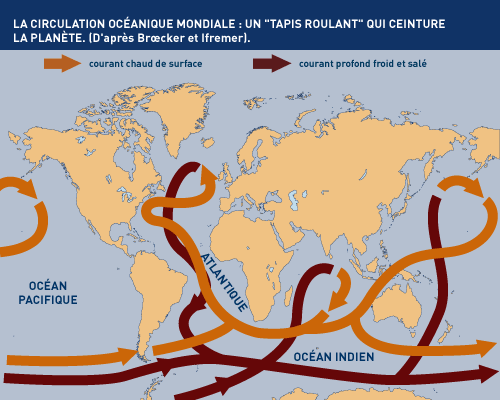
MARINE CURRENTS: REDISTRIBUTING HEAT
The world’s oceans are not immobile masses of water, they involve surface and ocean floor currents that keep water moving continually.
The surface currents (speed: 0.1 to 0.5 metres per second) are caused by the action of the wind. The deep currents, which are much slower, are caused by differences in the density of seawater (themselves due to salinity or temperature). All these currents are also deviated by the Earth’s rotation (the Coriolis effect).
Oceanic water in the tropics receives a great deal of heat from the sun. This warmer water is carried by surface currents towards the higher latitudes, where the heat rises into the atmosphere. As a result, the water cools and becomes heavier, convecting downwards and being carried back towards the tropics by deep currents (the North Atlantic Drift Current, for example).
All this means that the mass of oceanic water warms the climate in colder regions and lowers temperatures in tropical climes. So an understanding of the circulation patterns in the world’s oceans is essential to a better understanding of the Earth’s climate. Any variation in the ocean currents will have an impact on the climate.
FLOW RATES OF THE MAJOR OCEANIC CURRENTS :
> Antarctic Circumpolar Current : 130 Sv*
> Gulf Stream : 90 Sv
> Subsea cataract in the Denmark Strait : 2,5 à 5 Sv
> Bering Sea Current : environ 1 Sv
> All the world’s rivers combined : 1 Sv
* 1 Sv (Sverdrup) = 1 million cu. m/sec
THE ARCTIC OCEAN: STILL MANY MYSTERIES …
The Arctic Ocean is one of the least studied in the world. Although polar, it is totally different from the Antarctic Ocean in many aspects: its wide continental platforms, its active opening (dorsal), its extension to the pole, its large inflow of fresh water by the rivers, its own ice dynamics …
Water circulation, freeze-up and thaw processes are still very hypothetical. Modeling of the Arctic Ocean on computer poses serious problems; in particular, small scale phenomena are poorly known. However, this ocean plays a major role in the global climate – and even more so in Europe – because it produces a large part of the world’s deep water and must “respond” to human activities, most of them relatively close.
ARCTIC TIDAL STREAMS: PERTURBED BY COASTAL RELIEF
The tides in the Earth’s oceans are caused by the attraction exerted by the Moon and Sun on the mass of water. But this phenomenon on its own (even taking into account friction and inertia) is not enough to explain the huge tidal ranges (the difference between low and high tide water depths) along the coasts of Canada’s Nova Scotia (up to 16 metres in the Bay of Fundy). In fact, the pull exerted by the Moon alone is only enough to “lift” a tide by about 50 cm. The Sun, much bigger but also much further away, exerts enough attraction to lift it another 20 cm or so. The rest of the rise is the result of local amplification due to the shape of the coastline or the way the seabed shelves. This is known as “resonance”: at the inland extremity of a gulf or a gently shelving coastal inlet, for example, the movement of the tide is reflected back from the sides of the inlet/gulf and resonates (in forced oscillations, or rises and falls), thus amplifying the initial effect. The rise and fall of the tides generate currents or tidal streams that can be very strong, such as the rushing current between Barents and Edge Islands. When these tidal streams encounter the continental slope to the north of the Eurasian landmass, they set up a swirling current that can generate a vortex that reaches down to the seabed.
MAPPING THE ARCTIC TIDAL STREAMS
There are tides in the middle of the ocean too, or course, but unless there is an island there, you see nothing, because all ships rise along with the tide. Scientists measure the tides in mid-ocean by lowering to the seabed instruments that measure sea depth via the pressure of the water column. This can give an accurate depth to within 1 centimetre.
As the tides rise and fall, the tidal currents swirl to and fro twice a day. Scientists can map the direction and strength of their flow hour by hour. Oceanographers map the results in cotidal lines (lines joining the points where the tide has risen by the same proportion) and points where there is no flow at a given moment (amhpidromic points, from the Greek amphi and dromos = running around), with a new map for each “cotidal hour” or degree of longitude from the Greenwich Meridian.
PHYSICIST’S CORNER
> A liter of cold water is heavier than a liter of warm water, and a liter of very salty water is heavier than a liter of water that is less salty. These differences in density – also linked to the higher pressure at greater depths – can seem insignificant (a few dozen kg per ton or cu. m of water) but they are enough to cause a flow of water to move along as a higher or lower level. Physicists can monitor these flows by measuring temperature and salinity.
> A fall in temperature of 10°C increases the density of a given body of water as much as the addition of 2 g/l of salt or an added depth of 200-300 m. This means that polar surface water with a density of 1.027 would be less dense (1.022) at the Equator but more dense (1.050) at a depth of 5,000 m.
> In the Arctic, the key factor causing seawater flows to dive very deep is salinity rather than temperature. This is because the salinity of surface water is very low in this region (there is more rain/snow and more freshwater input from rivers), so ice can form on the surface before the density of the water is great enough to send it flowing downwards to the depths. Then, once an ice layer has formed, it blocks the ocean-atmosphere heat exchange, and thus stops the formation of deep ocean waters.
DID YOU KNOW ?
> The Sun and the Moon do not just attract the water on the Earth’s surface, they also exert their pull on every part of the landmass. This means there are also “land tides” that can lift whole continents about 30 cm twice a day. But the people living there never realise it because there are no stable local references: everything rises and falls together.
> If the Gulf Stream did not exist, Europe’s climate would be much colder. Scientists think that this has already happened during geological History (the late Dryas event, 11,000 years ago), when the Gulf Stream became weaker and triggered a colder climatic episode.
> There are zones at the bottom of the Pacific Ocean where the water is 2,300 yearThe tides slow the Earth’s rotation because they cause a loss of energy due to internal friction (the slowing has been estimated at 2/000 of a second per century). This means that when the dinosaurs roamed the Earth, the days were shorter than they are today because the Earth was turning faster: a year was 380 days of about 23 hours each. And 350 million years ago, when the first amphibians crawled out of the water on to the land, a year has 400 days of 22 hours each.
> The radioactive elements released during nuclear testing or the Chernobyl disaster can act as tracers to help scientists monitor ocean currents. For example, scientists have monitored the Greenland Current using tritium, an isotope of hydrogen.
TO FIND OUT MORE …
BIBLIOGRAPHY
- L’Arctique et l’environnement boréal, P. Avérous – CNDP, 1995
- Arctique (Océan) Encyclopedia Universalis
- Géostratégie de l’Arctique, Amiral Besnault – Economica-1992
- Les caprices des marées, Pour La Science – Août 2001
- La géographie de l’océan, J-R Vanney – Oceanis-1991
- Les cataractes géantes – Pour la Science n°138
- L’océan planétaire – Sciences et Avenir – Hors série n° 98-1994
- Gros temps sur la planète, J-C Duplessis – Odile Jacob-1990
- Glaces de l’Antarctique , C. Lorius – Odile Jacob-1991
- Oceanus – Woods Hole Oceanographic Intitution-1986
- Polar Regions – CIA-1981
- Le Système Terre, I. Razool – Flammarion-1993
- Les océans, J-F Minster- Flammarion -1994
- The Arctic Ocean Grand Challenge -1995
- Chercheurs sur l’Océan”, P.Avérous – Hachette -1981
Support the project with a donation
The Polar POD expedition is one of the stamp of the pioners, a human adventure coupled with a technological challenge, an oceanographic exploration never before carried out which will mark a milestone in the discovery of the oceans.
Thank you for your support !